Add the present Whitby Museum
Visit Pannett Park separately to learn more about the town and its collections. This is the Museum’s present location, not the Pier Road premises Bram visited.
Read more about Add the present Whitby Museum → Official Estate
Self-guided walks
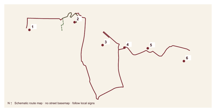
Follow Bram’s 1890 holiday from his West Cliff lodging, across the harbour and up the 199 Steps to the Abbey. Six stops pair the documented visit with the places he gave to Mina, Lucy and the Demeter in Chapters 6–8 of Dracula. About 2 km, with hills, cobbles and steep steps.
Lengths are approximate. Allow extra for crossings, detours and visits.
Numbered pins mark the stops. On your phone, you can tap a pin for a short introduction and photo, then tap the photo for full details. When you are done, click “Return to map”.
Showing your location is optional and needs no app. Tap Show my location and choose Allow for your blue dot. The pale circle shows estimated accuracy. Keep this page open and your screen awake. The Estate does not receive or save your coordinates. Map information and privacy.
Location is off.
Routes are a guide: follow local signs, crossings and current access conditions. Report a map issue.
1Main stopsAOptional stopsMain routeOptional detours
This is a steep route with steps. The 199 Steps are not a step-free route; arrange transport to East Cliff if needed. Check church and Abbey access before setting out.
Stop 1 of 6
Holiday lodging · late July–August 1890
Start with a holiday address before following the novel down into the town. Royal Crescent gives the walk a sense of the everyday Whitby from which its darker stories grew.
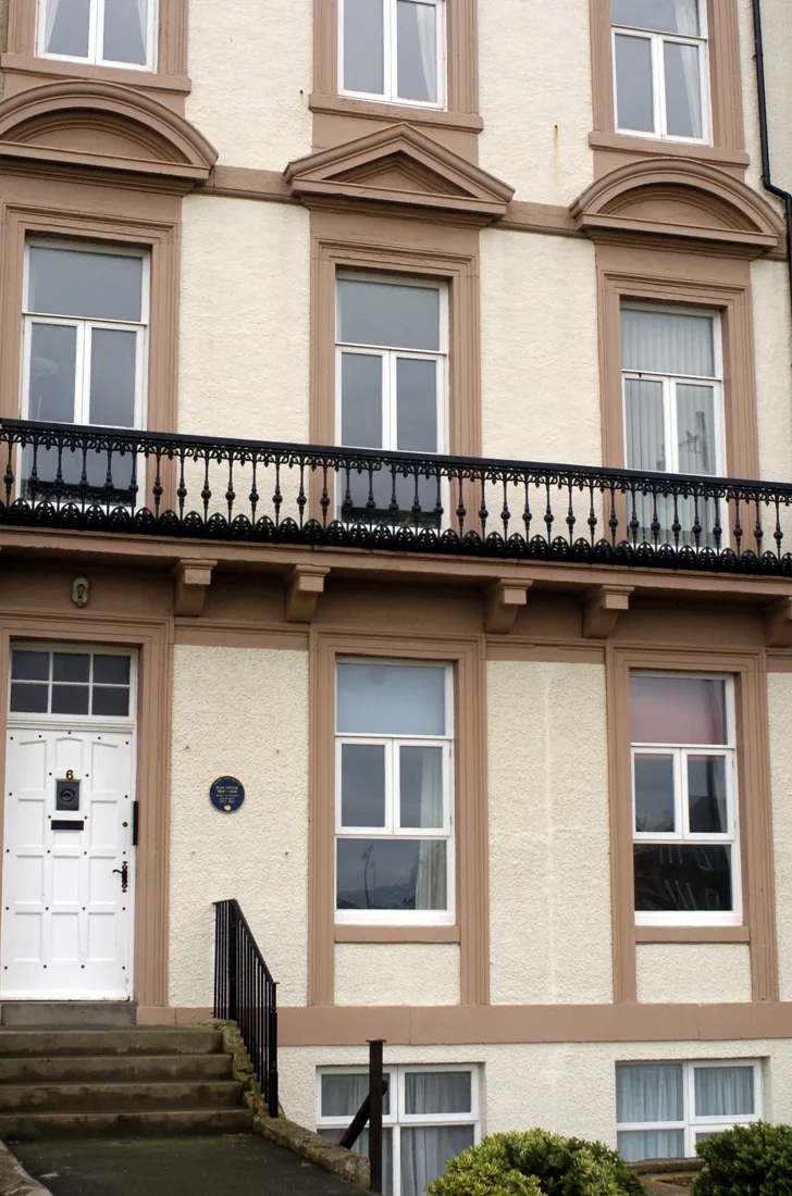
Look along the sweep of Royal Crescent to the plaque at No. 6. Bram arrived at Mrs Veazey’s lodging house here in late July 1890, by train from King’s Cross, and Florence and Noel joined him about a week later.
The family’s holiday took in Mulgrave Woods, Robin Hood’s Bay and the town’s Water Fete. Bram also read, walked and took notes, gathering material for a novel that would not appear until 1897.
That novel opens its Whitby chapters on this side of the harbour. Mina arrives on 24 July and drives up to “the house at the Crescent” where Lucy’s family have rooms. Later, the Count’s Whitby solicitor, Mr S. F. Billington, is given the address 7, The Crescent – next door, if the novel’s Crescent is this one.
The house number and commemorative plaque at No. 6, and No. 7 beside it. Then step back to take in the curve of the terrace, the setting Mina calls simply “the Crescent”.
“Lucy met me at the station, looking sweeter and lovelier than ever, and we drove up to the house at the Crescent in which they have rooms. This is a lovely place.”
“This cargo was consigned to a Whitby solicitor, Mr. S. F. Billington, of 7, The Crescent, who this morning went aboard and formally took possession of the goods consigned to him.”
Whitby Museum documents the lodging, the arrival and the family’s visit. Reading the novel’s “Crescent” as Royal Crescent is an inference from the text; no real Whitby solicitor called Billington has been traced.
Private property: view the exterior and plaque from the pavement.
Whitby Museum: Bram’s 1890 visit ↗
Next: Follow the West Cliff public streets towards the Whalebone Arch and the top of Khyber Pass, where the view opens over the harbour.
Stop 2 of 6
Later memorial · Holiday landscape · 1890; memorial seat · 1980
From one cliff, much of the next part of the walk is already in view. The harbour between the two heights becomes a stage on which the novel’s night-time drama can be followed.
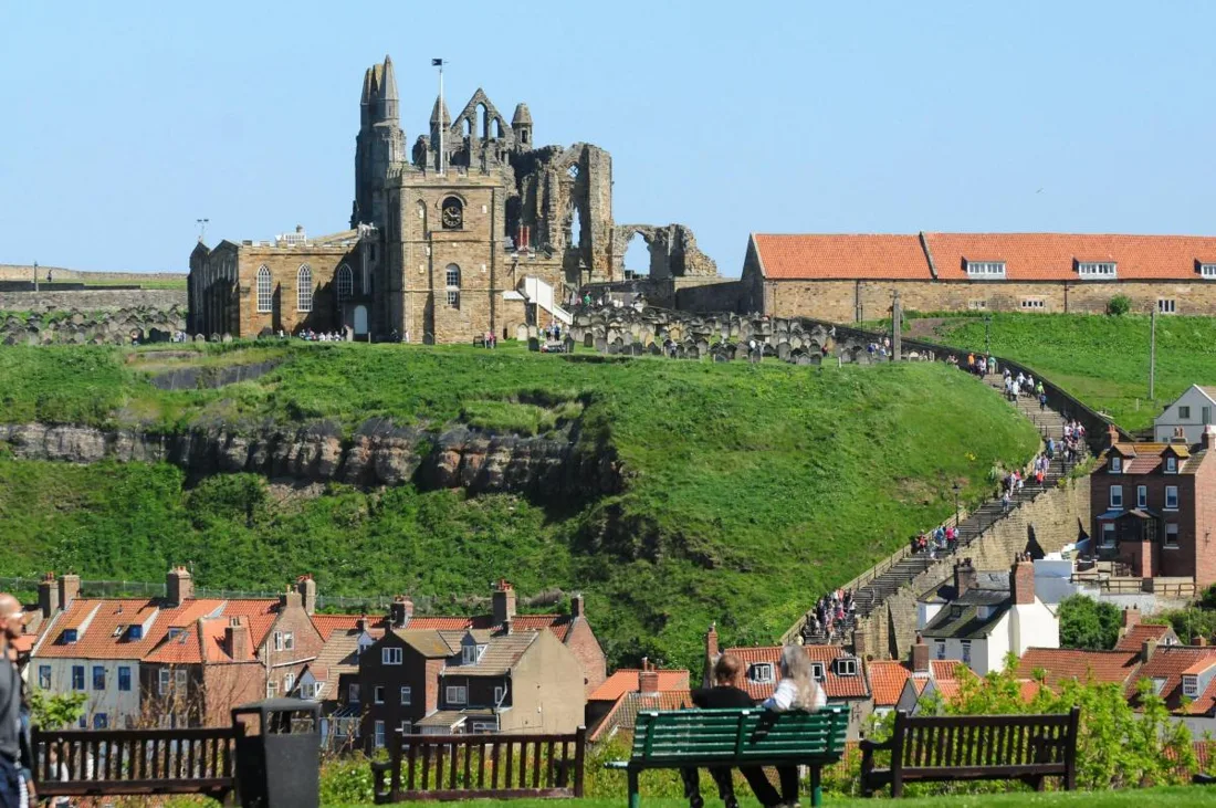
Look across the harbour to the East Cliff: the church of St Mary, its churchyard, and the Abbey ruin above. Bram lodged on this cliff in 1890, and this is the townscape he later gave to Mina and Lucy.
In Chapter 8 Mina wakes to find Lucy’s bed empty. She runs to the edge of the West Cliff as the clock strikes one and scans the far side by moonlight. A cloud passes, and she sees a white figure on their favourite seat.
Pick out the harbour entrance, the churchyard and the Abbey as separate shapes. The skyline has changed since 1890: Whitby Museum notes that the Captain Cook monument (1913), Caedmon’s Cross (1898) and the pier extensions (1911–13) all came later.
The Bram Stoker memorial seat near the top of Khyber Pass. It was erected in 1980 by Scarborough Borough Council and the Dracula Society, on the 68th anniversary of Bram’s death, and makes a fine viewpoint.
“At the edge of the West Cliff above the pier I looked across the harbour to the East Cliff, in the hope or fear – I don’t know which – of seeing Lucy in our favourite seat.”
“The setting sun, low down in the sky, was just dropping behind Kettleness; the red light was thrown over on the East Cliff and the old abbey, and seemed to bathe everything in a beautiful rosy glow.”
The 1890 holiday is documented; that Bram looked from this exact spot is a reasonable inference. The seat is a later memorial rather than one he used, and Mina’s night search is fiction set in the real townscape.
Use public paths. Some approaches have steps; choose a descent that suits your group.
Whitby Museum: the changing landscape ↗
Royal Geographical Society’s Discovering Britain trail (PDF) ↗
Next: Descend by Khyber Pass or the public streets to Pier Road and the quayside.
↑ Return to map from stop 2: West Cliff – the view towards East Cliff
Optional A · Lunch or tea
Connection attributed to the hotel · Optional refreshment stop
The Royal Whitby’s own history links Bram with its reading room and the views from West Cliff.
The hotel offers dining at the Fat Badger and lists an afternoon-tea menu. Reserve directly and allow extra time before continuing down towards Pier Road. This optional stop is a short diversion from the West Cliff section of the tour.
The reading-room connection is reported by the hotel. Bram’s documented 1890 lodgings were at 6 Royal Crescent.
Optional and paid. Check current tea sittings, menus, prices, accessibility and availability directly with the hotel.
The hotel’s account of its Bram Stoker connection ↗
Lunch, afternoon tea and reservations ↗
Next: Return to the West Cliff route, then continue towards Pier Road.
↑ Return to map from optional stop A: Royal Whitby – optional lunch or afternoon tea
Stop 3 of 6
8 August 1890; museum signature · 19 August 1890
The next clue to Dracula’s making lies among the quayside buildings, in the story of a reader and an old travel book. What began as holiday reading helped shape the novel’s vocabulary.
Look along Pier Road at the quayside buildings facing the harbour. In 1890 Whitby Museum occupied the top floor of the building now called Fusco’s Quayside, with the Subscription Library on the floor below. English Heritage uses the period name for the spot, the Coffee House End of the Quay.
Here Bram read William Wilkinson’s 1820 account of Wallachia and Moldavia. His note on it is dated 8 August 1890, and the book gave him the name Dracula. Eleven days later, on 19 August, he signed the museum’s visitors’ book upstairs.
The novel runs along this quay too. On the night of Lucy’s sleepwalk, Mina races down from the West Cliff, along by the fish-market and over the bridge, the only way across to the East Cliff.
The quayside frontages facing the harbour, then the swing bridge ahead: the crossing to the East Cliff that Mina takes in Chapter 8, and the one you take next.
“I did not wait to catch another glance, but flew down the steep steps to the pier and along by the fish-market to the bridge, which was the only way to reach the East Cliff.”
“He must, indeed, have been that Voivode Dracula who won his name against the Turk, over the great river on the very frontier of Turkey-land.”
Whitby Museum’s visitors’ book records the 19 August signature; English Heritage dates the Wilkinson reading to 8 August. The museum is now in Pannett Park, and the original doorway is not established, so the pin marks the street.
Busy quayside street: keep to the pavement and watch for traffic.
Museum’s account and visitor-book evidence ↗
English Heritage: Whitby and Dracula ↗
Next: Cross the swing bridge and follow Church Street, past Market Place, to Tate Hill Sands and the foot of the 199 Steps. The beach is an optional pause; the route stays on the landward streets.
↑ Return to map from stop 3: Pier Road – the historical library area
Stop 4 of 6
Fiction · Real shipwreck · 24 October 1885; fictional landing · Dracula, Chapter 7
A real wreck and an invented arrival meet on these sands. Keeping the two stories in view makes it easier to see how Bram transformed something Whitby remembered into the novel’s most dramatic entrance.
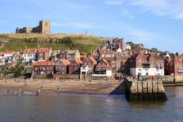
Look down at the sand below Tate Hill Pier, then up at the cliff and the churchyard leaning over it. On 24 October 1885 a real Russian ship, the Dmitry of Narva, grounded here with a ballast of silver sand.
When Bram arrived five years later, the town still remembered her. In Chapter 7 the schooner Demeter, from Varna, runs onto this same sand in a storm, her dead captain lashed to the wheel. An immense dog leaps from the bow and disappears up the cliff.
Now find the foot of the 199 Steps. The captain’s funeral climbs them to the churchyard, and in Chapter 8 Mina toils up them in the moonlight, searching for the sleepwalking Lucy.
Tate Hill Pier, the sand beside it and the foot of the 199 Steps. Compare the names: Narva and Varna, Dmitry and Demeter.
“the very instant the shore was touched, an immense dog sprang up on deck from below, as if shot up by the concussion, and running forward, jumped from the bow on the sand.”
“It turns out that the schooner is a Russian from Varna, and is called the Demeter. She is almost entirely in ballast of silver sand”
“They lead from the town up to the church, there are hundreds of them – I do not know how many – and they wind up in a delicate curve”
The Dmitry’s 1885 grounding is recorded, and English Heritage links her with the Demeter. Everything aboard the Demeter, from the dead captain to the dog, belongs to the novel.
Steep, exposed steps and uneven cobbles. The beach pause is optional; the route stays on public streets and the Church Stairs.
Read Dracula: Tate Hill and Lucy’s sleepwalk ↗
Tate Hill Sands: visitor information ↗
Museum’s account of Bram’s 1890 holiday ↗
English Heritage: the Dmitry and Demeter ↗
Next: Climb the 199 Steps to St Mary’s Church and churchyard. Take your time, and keep the route clear for others.
↑ Return to map from stop 4: Tate Hill Sands and the 199 Steps – Dracula comes ashore
Stop 5 of 6
Churchyard notes · 1890; Mina and Lucy’s churchyard · Dracula, Chapters 6–8
The inscriptions invite a slower kind of reading after the climb. Names cut into these stones became part of the working material for a story read far beyond Whitby.
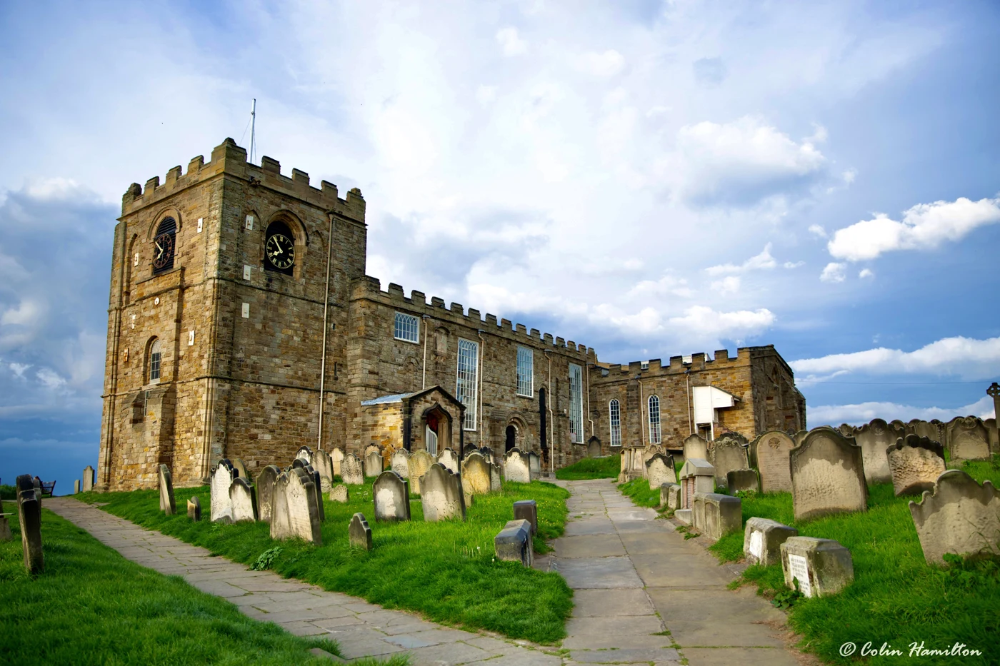
Walk among the weathered headstones on the cliff edge, with the harbour far below. In 1890 Bram went round this churchyard copying inscriptions; Whitby Museum counts more than ninety gravestones in his notes. One name he collected was Swales.
In Chapter 6 he gave it to an old sailor who sits with Mina and Lucy on a bench above the harbour. Mr Swales mocks the stones around them: many of the men they name, he says, were lost at sea and lie far away.
The churchyard darkens as the novel goes on. Swales is found dead on the same seat, his neck broken, and in Chapter 8 Lucy sleepwalks here while Mina sees something dark bending over her in the moonlight.
Inscriptions, many now worn, and the flat stones the novel calls “thruff-steans”. Then look back across the harbour to the West Cliff, where Mina stood searching for Lucy.
“Between it and the town there is another church, the parish one, round which is a big graveyard, all full of tombstones. This is to my mind the nicest spot in Whitby”
“‘Here lies the body’ or ‘Sacred to the memory’ wrote on all of them, an’ yet in nigh half of them there bean’t no bodies at all”
“there, on our favourite seat, the silver light of the moon struck a half-reclining figure, snowy white.”
Bram’s churchyard notes, including the name Swales, are documented. The bench, the deaths and the sleepwalk are fiction; no grave or seat here belongs to the novel’s characters.
A place of worship and remembrance. Keep to the paths and do not climb on gravestones.
English Heritage: Dracula and Whitby ↗
Next: Continue along the signed East Cliff route to the Abbey visitor entrance.
↑ Return to map from stop 5: St Mary’s Church and churchyard
Stop 6 of 6
Fiction · Gothic church · about 1225–50; setting in Dracula, Chapter 6
The Abbey brings a much longer span of history into the walk. Its surviving stonework and the stories told about it offer two different ways of reading this final landmark.
Look up at the east end of the Abbey church, its tiers of pointed arches open to the sky. English Heritage dates the first major Gothic building campaign to about 1225–50. Long before that, this headland held the seventh-century monastery associated with St Hild.
On her first day in Whitby, Mina looks up at this ruin and records its legend of a white lady seen at a window. Old Mr Swales dismisses such tales as fit only for trippers.
The silhouette you saw from the West Cliff now stands close at hand. It crowns the novel’s Whitby chapters: a real medieval ruin above the churchyard where Bram set Lucy’s night walk, and the skyline he knew in 1890.
The pointed arches and the exposed east end. Then turn towards the West Cliff and picture the same outline as Mina saw it, emerging from cloud by moonlight.
“It is a most noble ruin, of immense size, and full of beautiful and romantic bits; there is a legend that a white lady is seen in one of the windows.”
“I wouldn’t fash masel’ about them, miss. Them things be all wore out.”
Bram saw this skyline in 1890, and Mina describes the ruin in Chapter 6. The standing church is thirteenth-century Gothic; its literary fame is a later layer on a medieval site.
Abbey entry is paid and subject to opening times; check current access before you set out.
English Heritage: plan your visit ↗
English Heritage: the Abbey’s building history ↗
Whitby Abbey – official tickets and opening times ↗
The walk ends at the Abbey; the harbour walk and Abbey admission are separate, and the present Whitby Museum in Pannett Park, whose visitors’ book records Bram’s 1890 signature, makes a good addition.
Dates distinguish a home or holiday lodging from a workplace, research visit, fictional setting or later memorial. Where a complete residence period is not established, a dated record is given instead.
Holiday lodging, not a permanent home. The Museum dates his arrival and the family’s stay.
Evidence and background ↗English Heritage dates the Wilkinson reading to 8 August. The Museum’s visitors’ book records 19 August. Neither is the address of today’s Museum in Pannett Park.
Evidence and background ↗Visit Pannett Park separately to learn more about the town and its collections. This is the Museum’s present location, not the Pier Road premises Bram visited.
Read more about Add the present Whitby Museum →Chapters 6–8 provide a useful reading companion. Their events belong to fiction, not a diary of Bram’s own walks.
Read more about Bring the novel →